In the UK, raw sewage spills are no longer a rare occurrence: they’re an ongoing national scandal. According to conservation experts The Rivers Trust, only 14% of rivers in England can be considered to be in “good” ecological health. As if that wasn’t damning enough, a 2022 House of Commons committee report described England’s rivers as being “in a mess” and concluded that not a single river in the country remains untainted by chemical contamination, including the presence of pesticides and plastics. Meanwhile, statistics published by Surfers Against Sewage indicate that more than 584,000 discharges of raw sewage entered UK rivers in 2023.
It’s a dire situation, but hope is at hand. A consortium of British marine tech companies is preparing to launch a water quality-monitoring project across three key regional ports in South West England, with a trio of uncrewed surface vessels (USVs) providing the means of obtaining crucial pollution data. The project, dubbed ‘Smart Ports, Clean Waters’, will see the USVs deployed across rivers and estuaries in three port locations, namely Dartmouth, Falmouth and Plymouth. The consortium hopes to use the drones to build up an accurate picture of the extent of the local pollution problem.
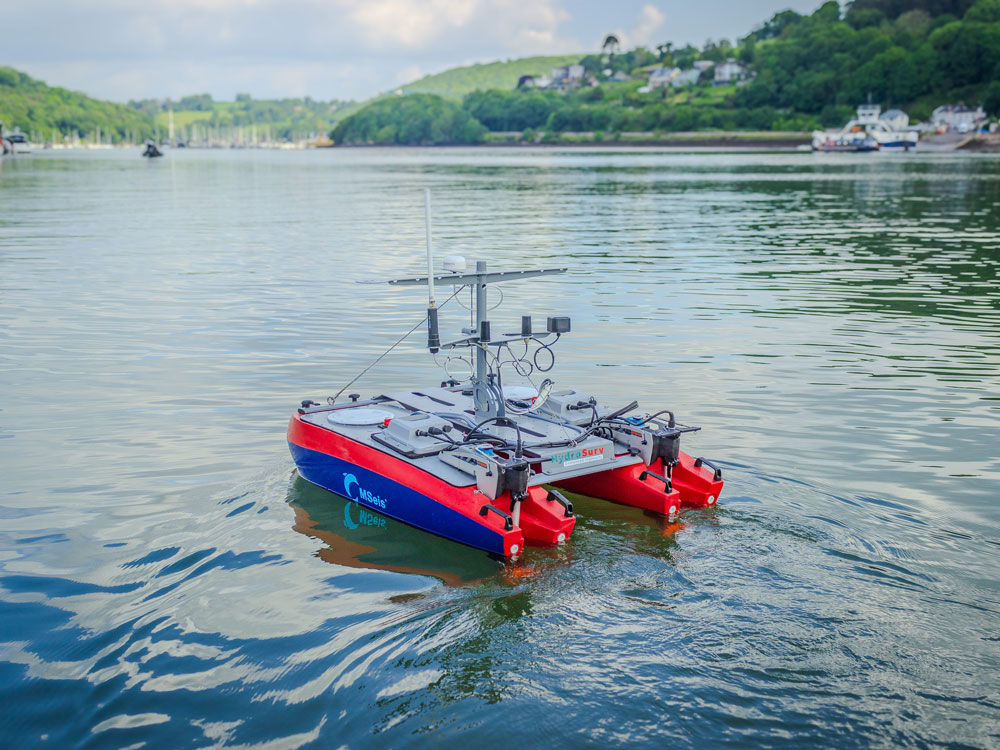
The initiative is being led by Somerset-based environmental services company MSeis, and fellow project partners include Chelsea Technologies, which will supply all sensors for the effort, plus Exeter-based USV developer HydroSurv, which will supply one REAV-16 USV unit to each of the three ports. The 12-month project will commence in October, although the partners are currently engaged in pre-campaign testing at the designated sites.
The REAV-16 is HydroSurv’s smallest USV type, originally launched in 2020. Measuring 1.58m x 1.17m, and featuring a dry weight of 60kg, the battery-electric drone can be carried and deployed by two people. This portability makes it an ideal fit for the streamlined MSeis team, which will deploy each USV once a week throughout the year-long programme. All three USVs will also be overseen by personnel in a dedicated remote operation centre situated at HydroSurv’s Exeter facility.
David Hull, HydroSurv CEO and founder, tells Ship & Boat International: “These uncrewed vessels use relatively high-grade GNSS positioning systems. Through those systems, they can follow waypoint tracks to ensure mission repeatability. This means that the data we’re collecting is truly representative of the same geospatial locations visited in previous deployments.” Another benefit of using electric USVs for this task, of course, is that the MSeis team does not need to rely on diesel-powered, crewed vessels.
Each REAV-16 is equipped with two Torqeedo Ultralight 403 electric outboards, powered by 915kW lithium-ion batteries. The batteries are positioned above deck to make it easier for users to hot-swap them – either when the USV returns to shore or from over the side of a small boat. The REAV-16 has an endurance of 4.5 hours between battery charges and moves at approximately 3knots – “a speed at which you can cover a fairly wide spatial area”, Hull says.
The USVs will gather water quality and eutrophication data on their weekly deployments, enabled by various sensors, including: a tryptophan sensor, as high levels of tryptophan in water are a good indicator of organic pollution, including sewage contamination; a chlorophyll sensor, to detect the presence of algal blooms, which can deplete oxygen in the water, suffocating fish and other creatures; and a fluorescent dissolved organic matter (fDOM) sensor, which detects broken-down vegetative matter, a potential indicator of excessive pollution and/or agricultural runoff. Hull adds: “The intention is that, by the end of the project, we get to use a single instrument with all sensor types combined, to optimise weight.”
The project is divided into four phases. The first three-month phase will see HydroSurv provide training to the MSeis team, as these personnel get up to speed on both the USV technology and the specifics of each working area. As the project progresses, HydroSurv will upload the weekly datasets gathered by the USVs from each harbour to a cloud-based geospatial data-viewing platform. Interested parties – including regulators, researchers and the general public – will then be able to access the platform over the course of the project, to keep up with developments as the USVs return more detailed information week-on-week.
Hull says: “A lot of decision-makers involved in hydrospatial and geospatial data don’t necessarily have specialist software skills. With the cloud-based platform, we’re trying to make the data-processing pipeline a really seamless experience for the very end user.”
While this particular project is South West England-specific, the partners intend to share their data with other researchers on a national level, before possibly taking their findings globally. As useful as the pollution data should prove to be, the process will also enable HydroSurv to refine the USV technology itself for future projects.
